

Quick answer
Customizing AutoCAD Map 3D toolset comes down to four layers we've mapped from Autodesk's 2027 help, as of November 2026: workspaces and CUIx files, styles, schemas, and the APIs. If you write code, AutoCAD 2027 add-ins target .NET 10.0, while 2021 to 2024 used .NET Framework 4.8. Start with one workspace saved in a partial CUIx file.
Customizing AutoCAD Map 3D toolset for a team touches four layers. Two steps are one-way: a schema after you click Apply, and the shared enterprise CUIx file, so we'd change the parts you can undo first. The AutoCAD Map 3D toolset is a set of geospatial tools built on AutoCAD that reads GIS and CAD data in one drawing.
The sections follow that order: what the toolset is, workspaces, and partial and enterprise CUIx files. Then come styling features in Display Manager and reusing styles through the Display Library, .layer files and templates. Feature classes and schemas come next, then which API to use, what we tested, the 13 rules our checker runs, and where to start.
Key takeaways
- Once you click Apply in the Schema Editor, earlier schema work can't be edited.
- A SQLite data store accepts only the schema name Default.
- Workspaces stored in a partial CUIx file can't be set current.
- An SDF or SQLite export keeps geometry and attributes but drops styling.
- AutoCAD 2027 add-ins target .NET 10.0, up from 8.0 in 2026.
What the AutoCAD Map 3D toolset is
Autodesk's own concepts overview sums it up: "AutoCAD Map 3D toolset bridges the gap between Computer Aided Design (CAD) and Geographic Information Systems (GIS)." Its features overview says it's "built on the latest release of AutoCAD® software." As of November 5, 2026, the same page adds: "It has all the features and functionality of AutoCAD, which is automatically installed with AutoCAD Map 3D toolset." On the Map 3D API page, Autodesk calls it "a specialized development platform for mapping, land planning, and infrastructure management applications."
The current release is AutoCAD Map 3D 2027. Its Map 3D 2027 release notes, dated March 25, 2026, send you to "System requirements for AutoCAD 2027 including Specialized Toolsets" for hardware. Autodesk's AutoCAD product and pricing page blocked our checker on November 5, 2026. So there's no plan price here. Open that page in a browser for the US figure. Two changes in the What's New topic for 2027 touch map data. You can now "Export feature layer data to KML format," and "Support for MrSID files is deprecated in this release." MAPIINSERT won't read them either. Check your raster folders for .sid files before anyone upgrades.
Customizing AutoCAD Map 3D toolset workspaces
Workspaces are the first layer you'll change, and the least risky. Autodesk's Customize Your Working Environment topic says "The layout of the ribbon, toolbars, and dockable windows is saved in a workspace." It suggests one workspace for building maps and another for map books and atlases, and the CAD manager topic, To Work With Customization, adds menus to that list. There are four to start from. The Workspaces tutorial topic says most tutorials and videos assume Planning And Analysis. 2D Drafting suits people who mostly edit drawing data, and Maintenance is for enterprise industry models.
Map Classic is the old menu-driven interface, where "Some new commands are unavailable from this workspace."
To build your own, open the Tools tab, then the Customization panel, then User Interface. In the Customize User Interface dialog box, right-click the Workspaces node and choose New Workspace. Click Customize Workspace, tick the ribbon tabs, menus and toolbars you want, and click Done. To make it the startup default, right-click it, choose Set Default, and click OK. The CAD manager topic adds two command-line switches for the same setup pass. The first, mapstatusbar followed by hide, removes the map status bar. The second, filedia set to 0, turns off file dialog boxes for scripts. If you'd like keyboard tips, our computer shortcuts guide covers the Windows basics your drafters probably use.
Partial and enterprise CUIx files for a team
Those workspaces live inside customization files. Autodesk's CUIx file overview says "Customization (CUIx) files define elements that make up the user interface." It names two designations, main and enterprise. The editor makes a backup the first time you change a CUIx file, so you can reset a bad edit to the shipped state. For your own tools, it's safer to use a partial file. The partial CUIx topic says it lets you change "most user interface elements in a separate CUIx file without changing the customization in the main CUIx file." You load it from the Customize tab or with the CUILOAD command.
Workspaces are the exception: "When a partial CUIx file is loaded, any workspaces defined in the file cannot be used."
Rename the partial file's customization group before you load it: the steps for loading a partial CUIx file say it can't share that name with the main file. And AutoCAD's workspace customization topic confirms that "only workspaces in the main and enterprise customization (CUIx) files can be set current." Once more than one drafter needs the same tools, the enterprise file becomes the shared layer. Autodesk's enterprise CUIx topic says it's "controlled by a CAD manager" and sits on a shared network location every user can reach. Our cloud storage comparison for small businesses covers where that share can live. AutoLISP comes along too: per the AutoLISP loading topic, an MNL file with the CUIx file's name loads automatically.
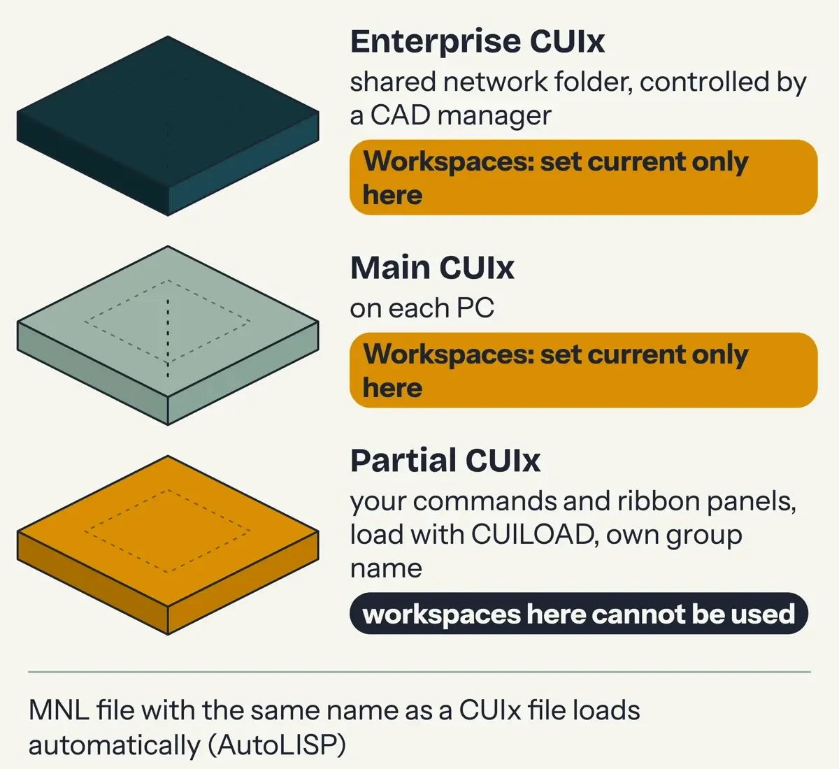 Diagram by DigitalTreed, from Autodesk's AutoCAD 2027 help topics on CUIx, partial and enterprise files, read November 5, 2026.
Styling features in Display Manager
Autodesk's help gives points, lines and polygons separate styling steps. Its Style Data topic says styles can combine symbols, such as "roads that display both a line style and a highway symbol." All of it happens in Display Manager, and the Display Manager topic warns that "Only layers that are turned on in Display Manager will appear in a legend." The symbol sources aren't the same for each geometry type. Autodesk's steps for point features accept DWG blocks, .layer and .xml symbol files, and raster images in GIF, JPG, BMP or PNG. For line features, Load takes a symbol library (.layer), a line style (.lin) or a vector symbol (.xml). The polygon steps cover fills, borders and pattern symbols.
Scale ranges switch a style as you zoom out: in Autodesk's composite road style exercise, a black 2 mm line under a dashed yellow line shows from 0 to 30,000. A plain black line covers 30,000 to 50,000. Past 50,000, the color is No Color, so roads don't draw at all. Each range starts exactly where the last one ends. Our checker tests for that.
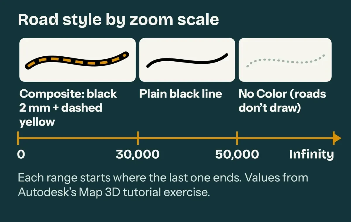 Drawn by us from Autodesk's Map 3D 2027 tutorial exercise on composite road styles, read November 5, 2026.
Themes go a step further and color features by value, and Autodesk's theming steps offer three numeric methods: Equal, Quantile and Jenks (Natural Breaks). Text values don't get that choice. The same steps say "Properties containing strings use an Individual Values distribution that does not allow the number of rules to be edited."
So if you theme water mains by pipe material, you'll get one color per material, and you can't set how many rules the theme creates.
Reusing styles: the Display Library, .layer files and templates
Those styles don't need rebuilding in other drawings, thanks to the Display Library. The Display Library topic explains that pasting a style into the library doesn't link it: "Only dragging from the Display Library to the drawing layer creates a referenced style." To share a styled layer with a coworker, save it rather than export it. Autodesk's topic on saving or exporting a layer says an SDF or SQLite export "contains geometry and attribute data, but no styling data." A saved layer keeps "its styling information and pointers to the data source," and the save steps give it a .layer extension.
An export also cuts the tie to the source: Autodesk says changes to the SDF or SQLite file "will not update the central data store."
Two built-in tools cut repeat work, and you won't need code for either. Autodesk's workflows topic lists a Batch-save .Layer Files workflow that saves each SDF file in a folder as its own .layer file. For new drawings, the templates topic names four map templates, map2d.dwt, map2diso.dwt, map3d.dwt and map3diso.dwt, for imperial (ANSI) and metric (ISO) units. The same topic says a template can hold "data connections, coordinate system information, and more." We'd save the team's settings into a copy of map2d.dwt.
Feature classes and schemas in the Schema Editor
Unlike styles, some schema steps can't be undone, so schemas are the part we'd plan on paper first. Autodesk's About Schemas topic says elements are built in order: the schema, then its feature classes, then their properties. The schema creation steps add: "You can add feature classes and properties, but you cannot edit your previous work." The Schema Editor reference lists new schemas for SQL Server, MySQL, Oracle or SDF, and says you can't create one for an existing SHP feature source.
SQLite is stricter. Its schema must be named Default, and it takes no description comments.
Feature classes follow a few rules from the same reference: for most providers, a feature class needs a unique identifier unless it inherits one from a base class. An abstract class can be a base class, but it can't hold features. Take a water network as an example: a shared Asset class can pass its AssetID property down to Hydrant and Valve. Each child class then gets an identifier.
Before you click Apply, export a copy. The export steps save a schema as XML or XSD from the Schema Editor toolbar, and the editor can import that file to build a second data store. If your data sits in database views, Autodesk's views topic says the native view must contain a primary key and use a spatial index.
Which API should you use for Map 3D?
You'll reach code last, and Autodesk documents two API families for it. The Map 3D API page lists "ActiveX, AutoLISP, ObjectARX, Geospatial Platform and Feature Data Objects (FDO)" and says the Geospatial Platform API is .NET only. The in-product Developer Documentation topic gives the same list plus ObjectARX Managed Wrappers. The API page splits them by data:
- APIs based on AutoCAD entities (ObjectARX, .NET, COM Automation, LISP) work with drawing objects, object data, topology and classification.
- The Geospatial Platform API works with features from FDO data sources only.
- FDO itself is the data access layer, exposed as C++ and .NET.
So pick by what your tool touches: drawing entities, GIS features, or both. Autodesk's .NET managed applications topic says AutoCAD-based products use "ObjectARX managed wrapper classes." That topic covers both VB.NET and C#. The AutoCAD API page also lists ObjectARX in C++, Visual LISP and ActiveX. Geospatial Platform samples sit in the Map 3D ObjectARX SDK's Map Samples\Platform folder.
Autodesk's managed .NET compatibility table sets the version targets: AutoCAD 2027 lists .NET 10.0, 2025 and 2026 list 8.0, and 2021 through 2024 list 4.8.
A loaded DLL also has to pass secure mode: the NETLOAD steps say that with SECURELOAD at 1 or 2, code runs only from folders in the TRUSTEDPATHS system variable.
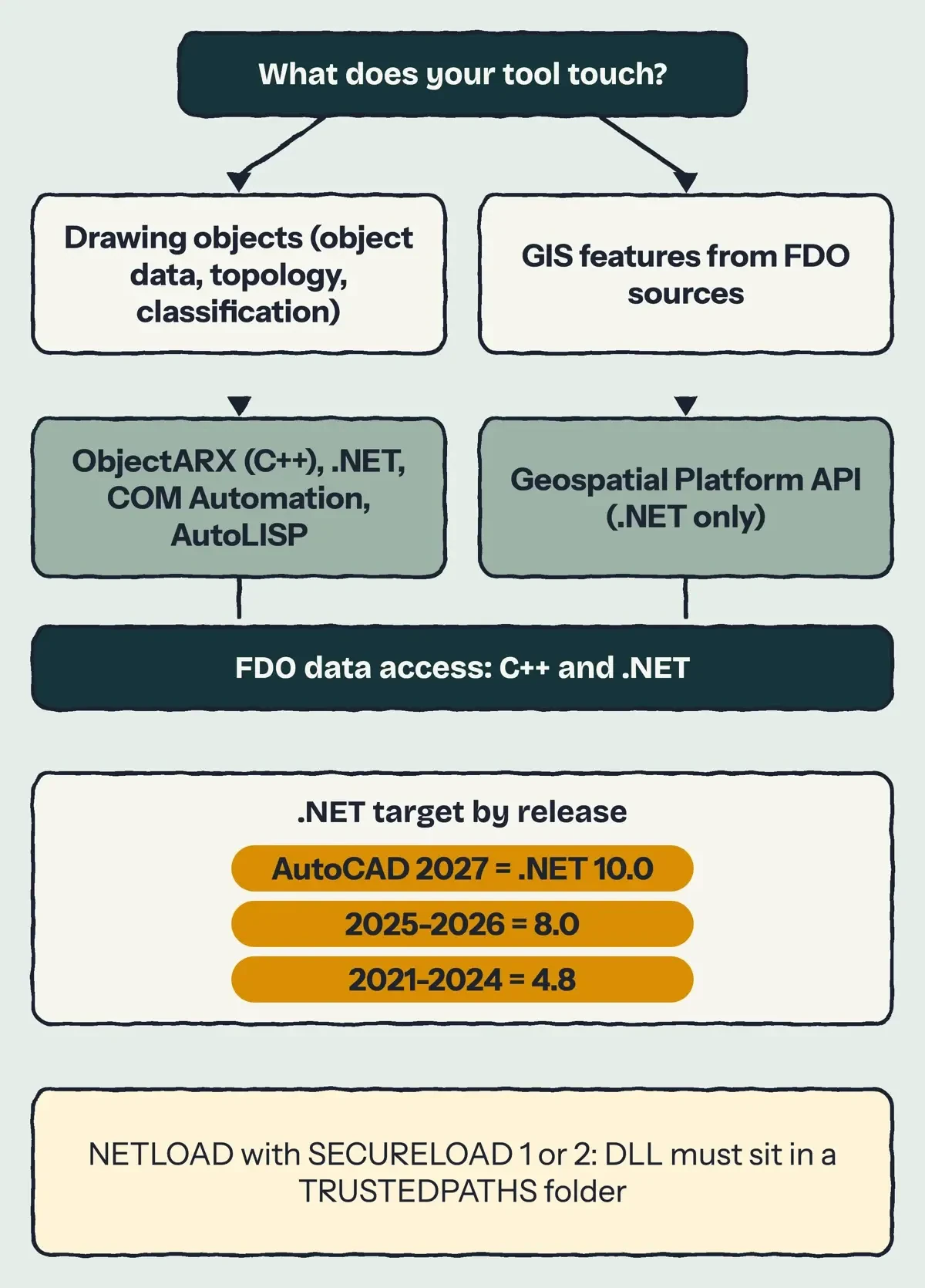 Diagram by DigitalTreed, from Autodesk's Map 3D API page and AutoCAD 2027 .NET help topics, read November 5, 2026.
Not every repeat job needs code, though. The Workflow Designer chains activities such as an overlay, a buffer and a plot, and it can prompt for values at run time or keep them fixed in the workflow.
Our no-code versus custom development guide walks through that build-or-configure choice, and our freelancing websites roundup covers Upwork and Toptal if you'd rather hire out a plug-in.
What we tested
We never installed AutoCAD. Our Python checker reads a plan and tests 13 rules from the sections above, each tied to a sentence it first finds on a saved Autodesk page. It doesn't call any Autodesk software or service. A first-draft plan for Quarrybend Water District (made up) passed 1 of 13; the fixed plan passed 13 of 13.
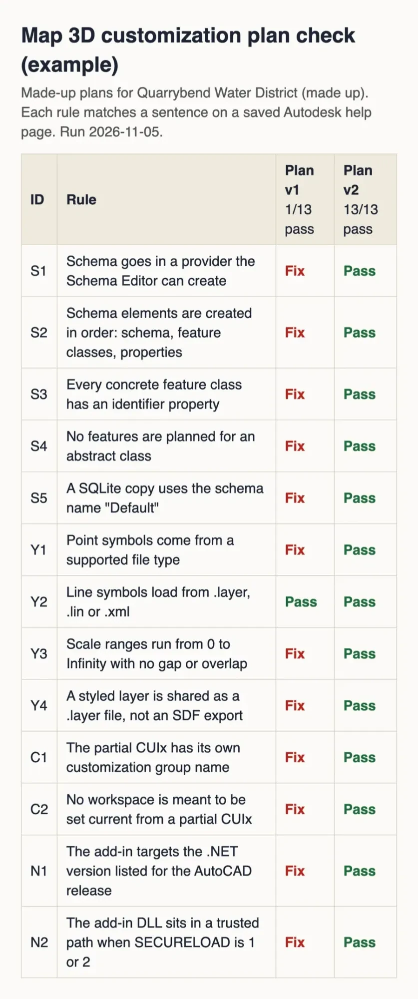 Screenshot: our plan-check report served on 127.0.0.1, November 5, 2026. Both plans are made up.
The 13 rules our checker runs
Each rule ties to a help topic linked above, so you can run the list by hand on your own plan. Plan v1 is the made-up Quarrybend first draft, and plan v2 is the fixed one:
| Rule | What it checks | Plan v1 | Plan v2 |
|---|---|---|---|
| S1 | Schema goes in a provider the Schema Editor can create | Fix | Pass |
| S2 | Schema elements are created in order: schema, feature classes, properties | Fix | Pass |
| S3 | Every concrete feature class has an identifier property | Fix | Pass |
| S4 | No features are planned for an abstract class | Fix | Pass |
| S5 | A SQLite copy uses the schema name "Default" | Fix | Pass |
| Y1 | Point symbols come from a supported file type | Fix | Pass |
| Y2 | Line symbols load from .layer, .lin or .xml | Pass | Pass |
| Y3 | Scale ranges run from 0 to Infinity with no gap or overlap | Fix | Pass |
| Y4 | A styled layer is shared as a .layer file, not an SDF export | Fix | Pass |
| C1 | The partial CUIx has its own customization group name | Fix | Pass |
| C2 | No workspace is meant to be set current from a partial CUIx | Fix | Pass |
| N1 | The add-in targets the .NET version listed for the AutoCAD release | Fix | Pass |
| N2 | The add-in DLL sits in a trusted path when SECURELOAD is 1 or 2 | Fix | Pass |
The only rule plan v1 passed was the line symbol check, because main-pipe.lin is one of the three file types that Autodesk's Load option accepts for lines. We wrote plan v1 with mistakes on purpose, and the checker caught all 12. Among them: an SVG point icon, a 5,000-unit gap between scale ranges, a SQLite copy named WaterNetwork, and a .NET 4.8 target for AutoCAD 2027. The checker doesn't take the .NET table from our typing; it reads it from the saved page.
Where to start, in order
These six steps run from ones you can undo to the two you can't. For a small team, we'd test each step on one PC before it goes on the network share:
- Build one team workspace from Planning And Analysis.
- Move custom commands and ribbon panels into a partial CUIx file with its own group name.
- Style the main layers once, with scale ranges from 0 to Infinity, and save them as .layer files.
- Save a .dwt template with the coordinate system and data connections.
- Write the schema on paper, export it to XML, and only then click Apply.
- Write code last, against the .NET version your AutoCAD release lists.
Schema Apply and the enterprise CUIx file wait until the team's used everything else for a week. Test any add-in the way our white box testing guide describes, and keep the version habits from our software engineering basics. If map work pulls you toward 3D visuals, our 3D animation career guide covers that path.
AutoCAD Map 3D toolset questions
Frequently asked
Can I still use the Map Classic menus?
Yes. The Select Your Default Workspace topic says you can't pick Map Classic as the default there, but you can switch to it with the workspace switcher.
Does Map 3D 2027 handle Cloud Optimized GeoTIFF files?
Yes. The 2027 What's New topic says "Interactions with Cloud Optimized GeoTIFF (COG) files are now significantly smoother."
Does the 2027 toolset still work with PostGIS?
Yes. The same What's New topic says the FDO PostGIS provider "Now supports PostgreSQL 18.0 and PostGIS 3.6".
How do I check which Map 3D version I have?
Type MAPABOUT. Autodesk's MAPABOUT topic says it "shows the version number and date" of the toolset.
How we made this guide: Every step and quote here traces to one of 38 Autodesk help and developer pages, saved as text on November 5, 2026. Our plan checker ran against those saved copies on two made-up plans. Facts checked by the DigitalTreed team on November 5, 2026.
First published January 2022 with paraphrased help text and a CAD training firm's ad copy. Rewritten November 5, 2026 from Autodesk's own 2027 help and developer pages, without the ad copy.
Sources
- Autodesk Help: Overview of AutoCAD Map 3D Toolset Concepts
- Autodesk Help: Overview of AutoCAD Map 3D Toolset Features
- Autodesk: AutoCAD Map 3D 2027 Release Notes
- Autodesk Help: What's New in AutoCAD Map 3D 2027 Toolset
- Autodesk Help: Customize Your Working Environment
- Autodesk Help: To Work With Customization
- Autodesk Help: Workspaces (tutorial)
- AutoCAD Help: About Customization (CUIx) Files
- AutoCAD Help: About Creating and Loading a Partial Customization (CUIx) File
- AutoCAD Help: About Enterprise Customization (CUIx) Files
- AutoCAD Help: About Workspace Customization
- Autodesk Help: Style Data
- Autodesk Help: Exercise 1, Use a composite style for roads
- Autodesk Help: To Theme Features
- Autodesk Help: About Saving or Exporting a Display Manager Layer
- Autodesk Help: Templates for Maps and Map Books
- Autodesk Help: Schema Editor
- Autodesk Help: To Create a Schema
- Autodesk Platform Services: AutoCAD Map 3D API
- Autodesk Platform Services: AutoCAD API
- AutoCAD Help: About Managed .NET Compatibility
- AutoCAD Help: To Load a Managed .NET Application


Comments
No comments yet. Start the conversation below.